
Fjallsjökull, Iceland
It's been over 3 months now since I spent 10 days road-tripping and exploring around Iceland, which I can only describe as other-worldly and/or magical. I thought for quite some time just how to post about my time there, giving the trip and the country proper representation...and I'm honestly not sure it's possible. There were just so many wondrous places and experiences during this trip, that I find it's really difficult to verbalize my thoughts and feelings in words. I suppose I would say this: Of all the places I've been (with the possible exception of Antarctica), Iceland is the one place where one can truly feel like an explorer. I suppose I would put New Zealand in there as well, as my experiences tramping around the South Island were some of my most rewarding and rich. There's just something so special and indescribable about Iceland that I don't think anyone can truly express on paper or in a journal post. It is somewhat cliche' to say, "you've just got to experience it for yourself", but truthfully, this really is the case here.
When C and I decided to make Iceland our vacation destination for 2017, we kept the plan very open. We made a checklist of a few places (some of the more famous/tourist spots) that we wanted to see, but otherwise, decided to sort of "wing it". We did each make a list of our own personal "must-see" spots, but otherwise, we wanted to surprise ourselves with the experiences. Our primary plan was to explore as much of the country as we could, by way of the famous Ring Road (and side-trips therein). We bought a really good guide book, one that had a focus on more remote locations (less touristy), and earmarked a few pages of interest. My one request (must-see) spot was to travel up to the Island of Grimsey in order to travel above the Arctic Circle. I wrote an entire post about this planned adventure earlier this year. Without re-hashing that post too much, the idea of this side trip, was that Grimsey Island represents the only part of Iceland that sits above the Arctic Circle, and having not yet ever ventured into the true "Arctic", I really wanted to go there.
Our general plan for this trip was to rent a small camper van that we would sleep in nightly, and then find hostels and campgrounds to shower in where available. We rented a small van from a place called Happy Campers, and they provided us with everything we needed. One thing to note about Iceland that everyone LOVES to remind you of, is that it can be expensive. BUT...it doesn't have to be. What we found was that even when traveling around Iceland during peak tourist season, is that if you have a camper van, and you shop for your own food, you can get by on a pretty meager budget. Where it gets expensive is with eating out at restaurants, shopping for gifts, and staying in hotels. If you stay in your camper vans (and campsites), and prepare your own meals, Iceland is actually relatively inexpensive. Of course with this said, our largest expense was definitely the camper van. We rented a very old model van, that was probably a bit too small, and had a very rough manual transmission....BUT, it was cheaper than getting a rental car with motel rooms by far. For those curious, our van cost about $150 USD / day. This sounds like a lot, but when you factor in that it's both a car and hotel room, it was worth it. Other than the ~$1500 we spent on the van, we saved about ~$1500 to use for the trip itself and we came back with a fair amount left. The ferry ride over to Grimsey was also a bit expensive, but also totally worth it...and HIGHLY recommended.
Our rental van came equipped with a solar charger, internal heater, working sink, working stove, and medium-sized cooler for food. We were able to buy several days of food at a time and it was a lot of fun prepping and cooking meals. In addition, the Happy Campers rental site has a free food shelf that includes food that other travelers left behind that wasn't used. We stocked up on a lot of this food before we left. When our trip was over, we ended up having our own leftover food that we re-donated to the shelf, so it all worked out. Our van even came with working wifi, so we could check our mail and various websites while driving...even in the most remote places of the country. Overall, the van was a bit cramped, but it wasn't too bad. The back had a bench for sitting, that could fold down to make a bed for sleeping. Each night, it took about 10 minutes moving our bags up to the front seats and then making our bed. There were a few cold nights that we would have preferred to just hop into a pre-made bed, but the extra effort was worth it considering the next size camper van was more than 50 dollars extra per night. Another bonus was that because we had so many blankets, we didn't have to bring sleeping bags, which saved on space in our luggage.

Our home for 10 days

View from the back, with the bed-seat in the "up" position
Something very important to note about Iceland for anyone reading this and thinking of making it your vacation destination. Number 1....it can be very busy depending on where you go, and is most expensive during the peak tourist season (July-August). Our last couple of days in Iceland were in early September, and prices everywhere dropped on the 1st. If you can swing it and go a smidge later...I would recommend going in early September.
Number 2....Icelandic weather is all over the place and it WILL ABSOLUTELY RAIN while you are there. Bring rain gear, and get used to the idea of "grey days". We were hoping for perfect blue skies every day, and for the first 5-6 days, all we saw was grey skies and constant rain. At first it really got us down, but we learned to live with it and decided to not let it ruin our trip. Thankfully we had some good Gore-Tex gear, and a positive attitude. We also found really good forecasting web sites, and were able to adjust our plan a little on the fly, in order to "get ahead" of cruddy weather. We skipped a few places on the Ring Road in order to get further around into some nicer weather. I would definitely recommend looking at the weather ahead of time, and be prepared to alter your plans a bit if you can....or be prepared to deal with lots of rain.
Our planned route was to effectively drive the Ring Road in a counter-clockwise direction starting in Reykjavik. Initially, we planned to hit the "Golden Circle", which is a popular tourist loop that people do out of Reykjavik, that includes some well-known destinations like Þingvellir, Gulfoss, and Geysir. Then from there, we'd continue along the Southern rim of Iceland and gradually work our way over to the big outlet glaciers of Vatnajokull. Then, we'd head up the Eastern coast and see some of the fjords eventually making our way up to the northernmost coast. Moving back west, we had a set plan to hit the towns of Akureyri and Dalvik in order to make our ferry up to Grimsey. Then depending on time, we planned to either explore some of the remote Westfjords, or venture out onto the Snaefellesnes Peninsula. Lastly, we had penciled in to spend at least one full day (our last day) in Reykjavik before heading to the airport and back home. For the most part we did stick to this plan, with several unplanned side trips, and a few alterations due to weather. We ended up only briefly exploring the Westfjords and instead spent two wonderfully sunny days out on the Snaefellesnes Peninsula.
As a side note, Iceland is generally broken into eight regional jurisdictions. We had decided that we wanted to at least set foot in each region during our trip.

Map of our 10-day journey (blue line was our route)

The 8 "regions" of Iceland
DAY 1: Reykjavik to Úthlíð
(Southern Peninsula Region, Capital Region, Southern Region)

Day 1 map (start at Airport, end at the "1")
We boarded our plane in Boston after 8PM...and settled in for the always exciting "red-eye" fun. When we booked our flights, we found a few options that were cheaper, but most were with budget airlines. The Icelandair redeye flights were the best deal overall, but it did mean arriving in Iceland, with likely very little quality sleep. Because of this, we agreed to make the first day very slow and easy. Our primary focus would be to pick up our van, making sure to get the full walk-through, and then visit a few nearby places taking naps if we needed. As long as we were headed somewhat East by the end of the day, we agreed that we'd be content.
When we arrived in Reykjavik, we learned something very quickly that would be a theme for most than half of our entire trip: IT RAINS A LOT IN ICELAND. More specifically, it is simply just grey a lot in Iceland. For some reason, we had just assumed we'd have these beautiful blue bird style skies while there. This was due to a lack of proper research on our part. We met our rental van shuttle driver, and were taken over to the Happy Campers headquarters where we got the full introduction to how things work in Iceland....i.e. gas, camping, parking, internet etc. Recently Iceland passed new laws about "Freedom Camping" due to the enormous influx of tourists with camper vans. It used to be perfectly fine to pull over anywhere and just camp for the night. Now, you are required to camp only in designated camping areas. Not a big deal really, but it does mean you don't have quite the freedom in your schedule that you may have wanted. Most camping areas have washrooms too, which means you have access to working bathrooms and showers...which is always a plus. Most sites were about 20 bucks a night (although some were free)...and none that we stayed at were too busy. Some of the places we stayed in more remote Iceland, were completely unoccupied. We paid extra to get an internet connection within our van. This sounds ridiculous, but it was amazing. Using our Iphones, we were able to navigate everywhere in Iceland without issue, AND while still being able to surf the web, and check email. This helped enormously when it came to looking for places to visit along our route and for checking on campgrounds. It simply doesn't makes sense to rent a camper van and NOT get the internet feature, especially considering it was only like 50 bucks extra total.
Upon leaving the camper site, we hit up a grocery store, stocked up on food, and then headed Southwest. We drove back past the airport (Keflavik) and drove onwards to the Southwestern corner of Iceland...known for it's expansive lava flows, and views of the tectonic plate boundary. We also wanted to walk to the coast to see if we had views of the remote Eldey Island. We drove past the Gunuhuver Hot Springs and the nearby geothermal plant, before making it the coast. It was my first real time near geothermal springs since visiting Yellowstone back in 2009 with my Geology field camp students. We also stopped at a few places marking the plate boundary between the North American and Eurasian plates. This was one of many obvious themes for our trip as the very nature of Iceland is that of a boundary between plates. Of course large tectonic plate boundaries are never perfectly neat/clean, they are always defined by "zones". So when you see an obvious broken surface that one might think is the specific split between two enormous plates, what you are actually seeing is one of many surface crack expressions of the entire rift zone. It's still really awe inspiring nonetheless, and does really bring a concept as huge as plate tectonics into terms of walking across a "Bridge between two continents!"

Boarding....

Welcome to grey/rainy Iceland

Bridge Between Continents!

More on the plate boundaries (in Icelandic!)

One of many surface expressions of the plate boundary

Some great geology signage at the bridge

Hot Springs!

More Hot Springs!

Iceland's Southwest Coast

If you really really squint...you can almost see Eldey Island

...there it is. Eldey Island

What Eldey actually looks like on a clear day with a telephoto lens

Valahnúkamöl - Well known Southeastern coastline of Iceland
Popular photo/tourist spot. We were the only ones there!
We left the Southwest coast, somewhat cold and wet, and headed back towards Reykjavik. We debated trying to see some of the city, but opted to skip it and leave it for the end of our trip as we were more interested in making it further east and towards the golden loop before dark. Our first scheduled stop was the National Park, and historic site of Þingvellir. Here you can see remnants of Icelandic settlements from over a thousand years ago as well as more beautiful surface expressions of the tectonic plate boundary. Before even making it to the site though, we had to pull over for a quick nap in the van. The red-eye had finally caught up to us both, were both exhausted from our lack of sleep, and it seemed like a good time to test out the sleeper. After a solid 2 hour nap, we were much more refreshed for a visit to the Park. By this time though, we already new our daylight was getting short, so we decided to hit up Þingvellir, and then set up our first camp site just short of the famous Geysir park. This way we could visit it first thing in the morning. When we did arrive at Þingvellir, we spent about 2 hours hiking around and taking pictures. It was still very cold and rainy, and so was a bit dreary, but it really was the perfect place to visit on our first day...as it didn't require too much walking or thinking for that matter.

Walking between the plates at Þingvellir

Beautiful pool of clear water at Þingvellir

Þingvellir visitor center built near site of original settlements

View across to the large volcanic dike

Visible ripples in the cooled lava

Another view at Þingvellir
We left Þingvellir and drove the short bit up the road to our first campground: Úthlíð. We pulled in (one of only 3 cars), unfolded the bed, cooked some warm dinner, washed up in the bath-house, and then settled in for our first warm night. Our camper came equipment with an independent heater that was powered from an independent battery. We set it on a delayed timer to keep us warm all night and both slept like logs.
(Southern Region)

Day 2 map (start at "1", end at "2")
I suppose if I had to sum up our second day in Iceland it would be somewhat along the lines of dreary, wet, and cold. It was about mid-day through our 2nd day that we realized we were in for less-than-favorable weather for potentially a large portion of our trip. We had found local weather web sites and none of them looked good, especially when we considered where we were headed. It was almost as though the bad weather was going to follow us. During day 2, the entire Northern part of Iceland was sunny, yet where we were was socked in with cold rain. Looking 3 days ahead when we'd be up North, the forecast was predicting cold rain for that area, with sun to the South. Needless to say, we were becoming a bit discouraged. Still, we tried to make the best of it through most of the morning and early afternoon. It was only in the late afternoon when our whimsical plan to try to ferry over to the island of Heimaey fell through, that we started to really reconsider our overall plan.
We started the day optimistically looking forward to hot springs, waterfalls, and glaciers. We knew we'd be exploring both Geysir and Gulfoss, but also Skogafoss, Eyjafjallajokull, and Myrdalsjokull. We were early to rise and get up the road the few miles to Geysir. This tourist spot is known for being home to several natural geysers and incidentally where the word "Geyser" originates from. We walked around exploring them all, and made sure to stay long enough to see some of the more regular geysers go off. While the namesake geyser "Geysir" is mostly dormant now, the nearby Strokkur geyser erupts every 30-50 minutes. We were there long enough to witness at least three eruptions. If you've ever been to yellowstone, this park was definitely very reminiscent.

Walking around Geysir Park

Litli Geysir (little geyser)

A geyser waiting to erupt

A milky colored hot bath

The namesake geyser "Geysir"
Strokkur (...wait for it...)
After Geysir, we drove up the road to Gulfoss, one of Iceland's most iconic waterfalls. It was quite lovely, but being cold and rainy, it was somewhat hard to truly appreciate it. We didn't spend a lot of time hiking around. After snapping a few photos, and taking in the gushing torrents of water, we went back to the car and headed South to finally pick back up with the Ring Road near the town of Selfoss.

Gulfoss

Gulfoss

Gulfoss
We turned onto the Ring Road trying desperately not to focus on the cold/rainy weather. We did what we do best and decided to improvise something crazy. As we made our way along the Southern coast towards the first of the big glaciers (the now famous Eyjafjallajokull), we made a whimsical turn down to the coast towards the port town of Londeyjahofn. From here, we'd be able to book a ferry trip over to the island of Heimaey. This was not on our radar at all, but after looking at the map, and knowing islands' unique geology, and that it would give us views of of the recently formed Surtsey Island we figured why not. We pulled into the town during a downpour in 40-50 mph winds and booked our ferry ride. A few minutes later we were told the ferry was canceled and it was at that moment that I'd say we hit our lowest point mentally of the trip. We were hoping our whimsical attitude would cheer us up, but it only served to disappoint us further. We headed back to the Ring Road and began heading further East. We didn't talk for a while and when we finally did, we both had the same thought.....Even though there were some beautiful glaciers and sights along the South Coast, we decided to make a concerted effort to "get ahead" of the bad weather. Forecasts had the Eastern and Northern parts of Iceland as relatively fair over the next two days, so we made the decision to push quickly through the sights along the South, and aim for blue skies.
We still made a few quick stops that night: One at both the Seljalandsfoss and Skogafoss waterfalls. We also stopped for a quick hike up to the Solheimajokull glacier (an outlet glacier of the Myrdalsjokull Ice Cap). All were lovely, but it was hard to not focus on the sideways cold rain pelting our faces. We made sure to stop along the road to gaze at the Eyjafjallajokull Ice Cap (and mountain). We spent hours practicing its pronunciation, trying to sound as authentically Icelandic as we could. For reference it's roughly pronounced: Eya-fyatla-yokutl. The hard part is the "yokutl" the "tl" sound at the end is made by putting your tough up against the inside of your teeth and blowing air through. It's hard to explain, and even harder to get right. It's almost a "Tssss" sound. Here is a video explaining it better than I can (Say Eyjafjallajokull).
After our Glacier hike, we decided to push out a huge chunk of miles to set us up for getting ahead of the weather. We drove across long lava field on our way to the massive Vatnajokull Ice Cap and eventually held up at the Hörgsland campground just past the lovely town of Kirkjubæjarklaustur. Go ahead, say that five times fast....

Seljalandsfoss

Seljalandsfoss

Skogafoss

Sheep above Skogafoss

Everybody practice now: "Eya-Fyatla-Yokutl"

Solheimajokull
(Southern Region and Eastern Region)

Day 3 map (start at "2", end at "3")
Day 3 started early. We opened the back door of our camper hoping to see clearer skies, but were again greeted with grey overcast and drizzle. We refused to let it get to us though and made way for Vatnajokull and the town of Skaftafell. We arrived at the car park and it was still fairly empty. We opted to first go on a short hike up to the Svartifoss waterfall, known for its columnar basalts. The hike was actually quite miserable and we were blasted with sideways cold rain. We did snap a few quick photos of the waterfall, but it was on the return back to our car that we finally hit the lowest mental point of our trip. We were ready to give up completely as we were tired of being cold, wet, and always in the part of Iceland that was getting the rain. We didn't talk much on the descent and when we got to the visitors center we just sat for a while drinking hot cocoa. We really didn't know what we were going to do next. After about 30 minutes we noticed there was a very short break in the clouds and that there was a walking path out the back door that would take you up to the toe of the Skaftafellsjokull glacier. We decided to take advantaged of the dry moments and we power hiked up to the glacier. Somehow, we managed to enjoy over an hour of dry air and faint smiles began to return to our faces. The outlet lake was littered with small icebergs. We played around the ice and even took some cool time laps videos

Svartifoss and the class columnar basalts

A grey dreary walk up to the Skaftafellsjokull terminus

Me in my element...

More glacier fun

A lone iceberg sentinel

The grey clouds finally show some texture
When we did finally leave Skaftafell, we noticed a road leading up to the neighboring Svinafellsjokull glacier and decided to explore there while the rain was still holding off.

Svinafellsjokull

Happy to be near glaciers and not getting rained on!

Glacier fun!

This is why you go to Iceland...
We continued on to explore Kvarjokull and Fjallsjokull Glaciers as well before finally coming to the enormous Breidamerkurjokull Glacier....which is several kilometers wide and one of the largest outlet glaciers of the massive Vatnajokull ice cap. What makes the Briedamerkurjokull so amazing is the large Jokulsarlon lagoon at it's base...that is home to hundreds of icebergs that have calved off of the terminus. These icebergs make their way to the ocean through a small outlet and will often get jammed up creating a scene like no other. We spent several hours exploring the many glaciers along the Southern Coast of Iceland...all while the weather gradually improved...

Kvarjokull Glacier

Kvarjokull Glacier

Nice camouflage

Fjallsjokull Glacier

Fjallsjokull Glacier terminus

Fjallsjokull Glacier terminus

Holding a piece of Fjallsjokull

Holding a piece of Fjallsjokull

A melted and sculpted piece of glacial ice...and its source

Icebergs jamming up in the Jokulsarlon lagoon

Icebergs

Icebergs

Icebergs

Icebergs that have made it out to the Atlantic Ocean

The grand scale..

An iceberg on the Atlantic beach
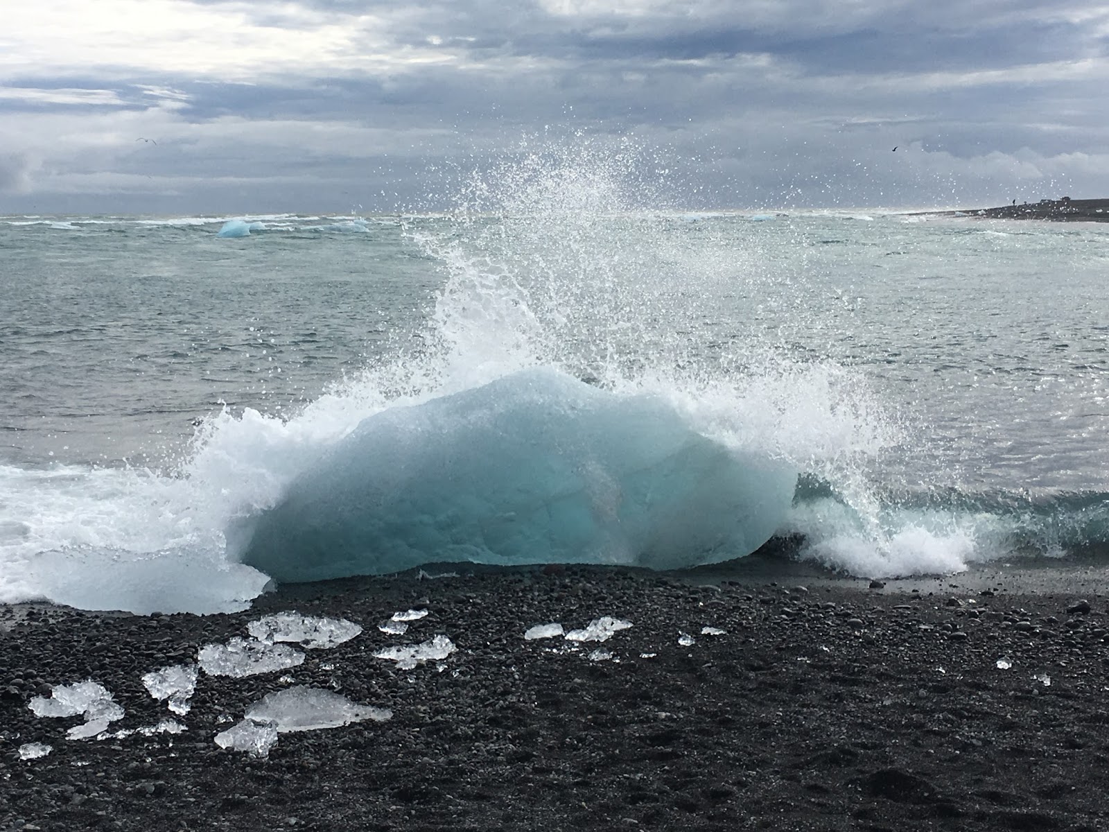
Ocean waves battering a beached iceberg

An iceberg seen through another
After we finally left the last glacier we made way for the Ocean town of Hofn. There we finally splurged and went out for our first real dinner. The first thing we noted during this dinner was the amazing soups every place in Iceland seems to have. At the restaurant, we both had a bowl of Icelandic Leek soup and it was very likely the best soup both of us have ever had. The second thing we noticed as that a dinner for two can be upwards of 80-100 US dollars. Ouch. After dinner we bought some groceries and starting making plans for where we were going to sleep. We looked up the weather forecast and noted that if we pushed the driving a bit hard during the evening to set us up for the Eastern Fjords, we could be on the Northern part of the island by morning where weather was predicted to be nicer. With that, we decided we'd drive the coast up to the Berufjordur Fjord and the tiny campsite known as the Berunes site. This was probably the most primitive of sites we'd stay at yet, but it was absolutely perfect. We rolled in late, parked on a grass spot overlooking the fjord, and slept with a smile. Iceland was really starting to get good. The next day we'd head north...

Our view of the coastal drive in the evening.

From a spot near our campsite at the Berunes.
(Eastern Region and Northeastern Region)

Day 4 map (start at "3", end at "4")
Day 4 was quite a different day than day 3. We spent a lot of time driving in and out of fjords, and through very small/remote villages...mostly on dirt roads. There were no big tourist destinations, just a lot of remote driving and exploring....exactly my kind of day. The weather was marginal, but not really raining, so we were happy. We also spent the majority of day 4 NOT on the ring road. We chose instead to visit the very northern portions of Iceland, far from the main highway.
Most of Day 4 involved whimsical stops along the road to explore, or hike random spots that we found beautiful intriguing. We drove up and over a less-than-ideal mountain pass road (Hellissheidl), which added some excitement too. We also spent some time in the town of Egilsstadir and learned of the famed Lagarfljót Worm that supposedly inhabits the eponymous lake. Most consider it to be the Icelandic version of the Loc Ness Monster.
Other than the beautiful morning drives through the fjords, the highlight of Day 4 was definitely the time we spent traipsing around the northern Melrakkaslétta peninsula. This peninsula features the northernmost point of mainland Iceland. There are two small spits of land that jut Northward that are essentially tied for this honor. On a recent survey, Rifstangi was actually measured at 68 meters further north, but many still consider Hraunhafnartangi to be the effective Northern point since there is a remote lighthouse there with a small jutting spit of rock that's easily accessible. It's easier to get to and only requires a few kilometer hike from the road. Sadly, for those looking to venture North of the Arctic Circle, even Rifstangi falls approximately 3 km South of the famed line. As I've spoken of many times before, the only way to truly visit land above the Arctic Circle in Iceland is to make a trip up to Grimsey Island (Incidentally, we did exactly this on day 6 of our adventure...see below).
Something else worth mentioning....is on the hike from the road up to the lighthouse of Rifstangi, there is a distinct and large pile of stones set up as some sort of marker. These stones are actually an ancient burial mound known as: Þorgeirsdys, or the Burial Mound of Þorgeir, a Viking Age warrior. The story of Þorgeir Hávarsson is quite fascinating and worth a read. He was an 11th century Icelandic warrior and supposedly defended himself bravely in battle, killing 14 of his enemies. The burial mound near Rifstangi is allegedly the ACTUAL burial mound of Þorgeir....meaning his physical body was buried there. Crazy!
We also somehow managed to stumble across a bizarre sculpture celebrating the Northern Lights and the Arctic environment.... located in the remote town of Raufarhofn, the Arctic Henge, or Heimskautsgerðið, can be seen for miles. It was rather surreal pulling into the tiny remote town, and seeing this huge stone sculpture very reminiscent of Stonehenge.
After our visit to the Northern bits of Iceland, we swung around the Melrakkaslétta peninsula and finally made camp at the Kopasker campsite. It was a very tiny site that was essentially just a field to park in...with a small bathroom house. We pulled in late and slept well. Our plan for the next day was to enjoy Northern Iceland, and then set ourselves up in Dalvik for our eventual ferry trip up to Grimsey!

Early morning fjords with sheep!

More beautiful valleys

A Misty morning in the fjords

A rocky sea coast near Vopnafjordur

Exploring the rocks near the coast

On a quiet beach with some sheep

Northern Icelandic expanse

The tiny northern town of Raufarhofn

Lighthouse at Raufarhofn

Arctic Henge, Heimskautsgerðið

Arctic Henge, Heimskautsgerðið

Northern Iceland

Our hike to Hraunhafnartangi

Þorgeirsdys burial mound

Northernmost sheep of mainland Iceland, Hraunhafnartangi

Lighthouse at Hraunhafnartangi

An old shelter at Hraunhafnartangi

The northernmost spit of Hraunhafnartangi
DAY 5: Kopasker Campsite to Dalvik Campsite
(Northeastern Region)
A lot of amazing things happened on Day 5, and most of it completely unplanned. We toured bubbling mud pots, hiked past steaming vents, played around volcanic flows, gazed into blue volcanic pools, climbed down into tectonic rifts, and watched an amazing sunset during a clear and cloudless evening. With that said, the absolute highlight of Day 5 for me was my first experience of witnessing the true Northern Lights. I have seen faint wisps of the Aurora on a few occasions, but never the dancing, green and vibrant light show that you often see in video clips online. On the night of our 5th travel day, we both stared at the sky, much like we did during the eclipse, in awe of something magical and fantastic. It's still hard to believe that I witnessed what are probably the two most amazing celestial events within weeks of each other: A total solar eclipse, and a full Aurora display. The other thing of note about day 5 was that we finally got amazing weather. The day started out a bit cloudy, but by mid-day, we were awash in warm sunlight and clear skies. It was finally the day we were hoping for. We had finally caught up to the good weather.


For reference here was the Aurora forecasting site we used to later "chase the Northern Lights":
http://www.swpc.noaa.gov/products/aurora-30-minute-forecast
http://www.swpc.noaa.gov/products/aurora-3-day-forecast

Day 5 map (start at "4", end at "5")
We started the day leaving the Kopasker campsite in what appeared to be another rainy/misty day. Our goal was to simply head south back to the Ring Road, and then make our way back West so that we'd eventually end the day in the northern port town of Dalvik...just north of Iceland's 2nd largest city: Akureyri. Our first fun decision of the day, was when heading south out of Kopasker, we opted to take the less-traveled backroad (862) south to the Ring Road, rather than the more established route (864). This 862 road was not an "F-road", so we were ok to drive on it, but it was definitely quite primitive and made for some fun/bouncy travel. Needless to say, we lost many a stray spoon and fork in the back of the van that morning as various bits and pieces flew around after each big road bump.

Dettifoss

Veiw from upstream of Dettifoss
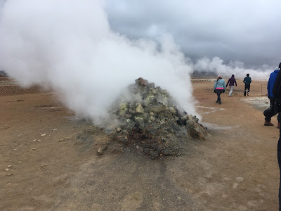
About half-way down 862 we stopped to see another famous waterfall: Dettifoss. Again, it did not disappoint. It seemed like me might be in the grey weather again, but as we hit the Ring Road and headed West, the skies finally starting showing signs of breaking. Our next target was the area around Lake Myvatn. We knew according to our basic guide book that there would be mud pots, hike-able craters, and exposed rifts to explore. As we approached the area known as Hverir, we were gleefully excited to see so much activity. While our previous trip to Geysir was impressive, we found Hverir much more rewarding. We toured mud pots, fumaroles, steam vents, and climbed up a steaming mountain side, It was incredible and not too crowded.

Approaching Hverir Mountain and volcanic area

Hiking around Hverir

Steaming Vent

Panorama from Hverir

Mud pot

More steaming areas

The ground is hot yo!

A wide field of steaming vents

View from the top of the mountain back down on the parking area

Even the top of the mountain was steaming

More mud pots
After we left Hverir, we drove across the street to the Krafla area. There is a large geothermal power plant there that we wanted to see as well as expansive lava flows and open rifts related to the tectonic plate boundary. There have been many eruptions in this area over the past few centuries and it is one of the few places that you can see what I consider "fresh" lava flows. We hiked all around taking in all that we could. The ground was warm in many places and you could clearly see the extend of the last lava flow. In addition, when we found an open rift in the ground, we couldn't resist climbing down into it. Again, tectonic plate boundaries are not perfect and these rifts aren't literal splits between plates...but it's about as close as you can get to actually standing between "continents". It felt like we found a crack that leads to Hell. It was quite spooky, but also incredibly fascinating.

Map of the Hverir / Krafla area

Krafla Power Plant

Krafla crater lake

Lava field in the background

Bubbling mud pot

Freshly cooled lava

Feeling the hot ground

Steam rising from an actual rift separating the tectonic plates

Descending into Hell

Look ma...we're between continents!

Another recent crater
When we left Krafla, it was getting near sunset...and yes, we could actually tell. The sky had finally opened up and we were greeted with the most beautiful blue sky. We took the scenic drive around Lake Myvatn and stopped at the Hverfjall crater for a quick evening rim hike. On our way out C noticed a large fault scarp extending for miles and had me take a photo of her posing on it....for posterity of course.

Looking down from the top of Hverfjall Crater

Standing on a fault scarp. You can see it extend through the crater in the background

A rough line tracing the fault scarp
(disclaimer: I study ice not faults, so I probably drew some of it wrong)

Photo taken at the base of the Hverfjall Crater
We stopped at the side of the lake and cooked the best vegan chili I've ever eaten in my life, and lounged in our chairs to watch the amazing sunset over the lake. We didn't want to leave. Every miserable rainy moment up to this point was forgotten and we were as happy as could be. Iceland was officially beyond compare.

Our view during dinner
We left our dinner spot and headed the rest of the way around the Lake. It was getting dark now so we were in for a late drive over to Akureyri and eventually up to Dalvik. We didn't care though as the beautiful sunset was worth it. We made quick time over to Akureyri and drove through "downtown". It was the first time on our entire trip that we had to stop at a red light...which was weird. We drove up the Eyjafjordur fjord up to Dalvik rather quickly and pulled into the Dalvik campsite at about 9 PM. It was later than we'd hoped, but all we had to do in the morning was drive the 1 mile down to the ferry dock and hop on a boat bound for Grimsey Island.
We parked at the campsite (which was really just an open field with small bath house in the middle). We converted our van for sleep and I began to make the slow walk over to the restroom to brush my teeth and prep for bed...when it happened.
I looked up and it was like nothing I'd ever seen before. I saw dancing whisps of green light moving faster than I ever thought possible. It was almost as if I was looking through some strange kaleidoscope toy. Weird squiggles of light were moving like snakes...quickly and with purpose. And then spreading out into whispy waves. What was so incredible was that rather than curtains or blankets of light, what we first saw was a central point of origin. All of the green colors were originating from a single focal point and emanating outward from there. It was almost as if Earth itself had turn on it's warp drive. Eventually that behavior stopped and the lights became more curtain-like (as seen in the pictures below). I only managed to snap a few pictures because I was just too much in awe to go get my camera. I didn't want to miss a second. I remember calling for C "Get out here quick...it's crazy!" She came out like..."what are you going on about...." and then her jaw dropped just like mine. We both were stood there in that field, motionless, freezing our butts off, but too amazed to care. Neither of us talked, we just gazed. It was magical.
It only lasted for a few minutes, but when it was over we both looked at each other and knew that the entire trip to Iceland was so completely worth it. We went to bed smiling and happy that night.
Deep down I was also giggling because I knew the next day, I'd finally be venturing above the Arctic Circle, just like I had planned so many months before!

Northern Lights (as seen from crappy iPhone)

Northern Lights (as seen from crappy iPhone)
For reference here was the weather website we used to alter our itinerary: http://en.vedur.is/weather/forecasts/areas/
For reference here was the Aurora forecasting site we used to later "chase the Northern Lights":
http://www.swpc.noaa.gov/products/aurora-30-minute-forecast
http://www.swpc.noaa.gov/products/aurora-3-day-forecast
------------------------------------------
The second half of our trip would be just as magical as we'd explore areas of Northwestern Iceland and the Snaefellsnes Peninsula. We'd see the Northern Lights again, and explore all sorts of remote and interesting areas. The good weather trend would also continue. On our final day we explored the wonderful city of Reykjavik and ended our trip right back where started. Part 2 coming soon.
My 2017 year-in-review post is in the works too....a bit behind...but coming along.
No comments:
Post a Comment